File:Map pdrydia 2igala6.png
From RPGWW Wiki
Map_pdrydia_2igala6.png (608 × 535 pixels, file size: 83 KB, MIME type: image/png)
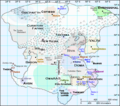
The most recently created continental map of Igala (Gaera Main), 1315. Version 2.6.
File history
Click on a date/time to view the file as it appeared at that time.
| Date/Time | Thumbnail | Dimensions | User | Comment | |
|---|---|---|---|---|---|
| current | 02:46, 27 May 2007 |  | 608 × 535 (83 KB) | Kelne (Talk | contribs) | Subtly different map. Temporary, pending discussion. |
| 20:18, 16 March 2006 |  | 608 × 535 (74 KB) | Pdrydia (Talk | contribs) | The most recently created continental map of Igala (Gaera Main), 1315. Version 2.6. |
- You cannot overwrite this file.
File usage
The following 3 pages link to this file:
